<8>整合功能
# <8>整合功能接口:
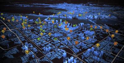
## --- 实时元素功功能:
----------*根据实时动态数据,可视化数据元素*
---
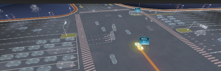
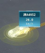
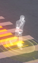
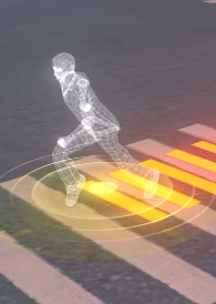
### ==8-1-a-1==:实时更新道路:机动车,非机动车,行人等信息
**接口方法名**:==STU_UpdateRoadPropData==
**参数说明:**
>i< ++**==intervalTime==**++ > 建议设置1000毫秒 到 2500毫秒,传参数的数据也按这个间隔时间的数据调用接口;如intervalTime = 2000,就是2秒调用一次这个接口,数据也要是间隔2000毫秒的;
< **++==id==++** > 三维标签唯一id,不要用 "all" , "-", 以及特殊敏感字符,通过此id查询查询并激活相应标签;
< **==++type++==** > 目标体类型,"car_1, car_2, car_3, car_4, human_1, human_2",依次为:"大型车,中型车,小型车,非机动车,行走的人,跑步的人";
< **++==longitude==++** > 经度;
< **++==latitude==++** > 纬度;
< **++==height==++** > 高度;
< **++==rotation==++** > 目标体旋转方向,0-360度,0的朝向是正北面,顺时针方向;
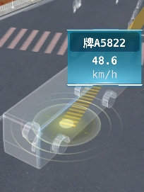
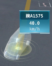
< **++==speed==++** > 目标体速度,单位m/s;
< **++==licensePlate==++** > 车牌,可为空;
< **++==info==++** > 速度单位,可为空;
< **++==cameraName==++** > 摄像头名称,可为空
< **++==line==++** > 轨迹点数据,起始经纬度点到尾点,至少2个点,可为空;
< **++==showInfoPanel==++** > 是否默认显示单体信息面板,默认不显示,true显示,false隐藏;
**< type >参数 图示:**
|car_1|car_2|car_3|car_4|human_1|~~human_2停用~~|
|-|-|-|-|-|-|
|大型车1|中型车2|小型车3|非机动车4|行走的人1|~~跑步的人2~~|
|||||||
**参数示例:**
```
{
"intervalTime": 1000, //每次调用数据间隔时间(毫秒单位)
"showInfoPanel": true, //是否默认显示单体信息面板
"data": [
{
"id": "as2532", //实例id;
"type": "car_3", //类型;
"longitude": "120.2120119900",
"latitude": "30.2084083000",
"height": "0",
"rotation": 0,
"speed": 0,
"licensePlate": "蓝浙AQ87T2",
"info": "",
"cameraName": "Camera 01",
"line": [ //车辆历史轨迹数据
{
"longitude": "120.2120119900",
"latitude": "30.2084083000"
},
{
"longitude": "120.2120119900",
"latitude": "30.2084083000"
},
{
"longitude": "120.2120119900",
"latitude": "30.2084083000"
}
]
},
{
"id": "fgd88",
"type": "car_2",
"longitude": "120.2120119900",
"latitude": "30.2084083000",
"height": "0",
"rotation": 30,
"speed": 65,
"licensePlate": "蓝浙AQ5528",
"info": "危险驾驶",
"cameraName": "Camera 01",
"line": [
{
"longitude": "120.2120119900",
"latitude": "30.2084083000"
},
{
"longitude": "120.2120119900",
"latitude": "30.2084083000"
}
]
},
{
"id": "tff65",
"type": "car_1",
"longitude": "120.2120119900",
"latitude": "30.2084083000",
"height": "0",
"rotation": 90,
"speed": 35,
"licensePlate": "蓝浙AQ878896",
"info": "",
"cameraName": "Camera 01",
"line": []
}
]
}
```
>i 返回参数:
{
"method": "STU_UpdateRoadPropData",
"exception": null,
"data": "success"
}
---
### ==8-1-a-2==:清除道路实时机动车,非机动车,行人等信息
**接口方法名**:==STU_CleanRoadPropData==
>i无参数
>i 返回参数:
{
"method": "STU_CleanRoadPropData",
"exception": null,
"data": "success"
}
---